- Screen Colours:
- Normal
- Black & Yellow
Westleton Common
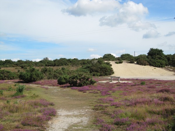
Photo Juliet Bullimore.
Westleton Common was purchased by the Parish Council in 2003 with substantial help from the Heritage Lottery Fund. The Common covers 17.95 ha. and is split into three parts divided by Bakers Lane and Mill Street with a small triangle of land between these two roads included in the Common. The Common is registered under the Commons Act 1899.
The aim of the management of the Common is two-fold. First it is to maintain the area as an open space for use and enjoyment by parishioners and others. Secondly it is to manage the habitat to maintain and increase the important wildlife species, in particular the Silver-Studded Blue butterfly for which the Common is of national importance.
Westleton Common Advisory Group
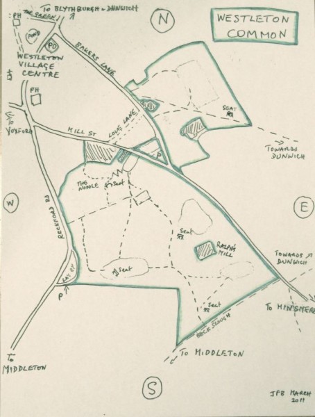
Installation of drop-down posts on the footpath leading to the Common
We intend to improve access to the Common for emergency vehicles.
The two wooden posts on the footpath leading from the storage container and parking area on Mill Street onto the Common will be modified so that, in an emergency, they can be dropped down more or less flat. These posts will be secured in their normal upright position using digital locks. The code to the locks will be issued to the emergency services only (Suffolk Fire and Rescue and East of England Ambulance Service). This code will not be available to the general public, although members of the Common Advisory Group will have them. The locks on the posts will be of a design that can be cut with bolt cutters if the first emergency vehicle on site does not have access to the codes.
The vegetation adjacent to the path will not be cut back and the path will not be widened. A pair of wooden posts to the right of the path a few metres beyond the posts will be removed. In the event of an emergency the drop-down posts can be opened, and the emergency vehicle can drive through the undergrowth onto the Common. It will be necessary to ensure that the vegetation does not become so dense as to inhibit the emergency access; this would be done as part of normal maintenance in line with the management plan.
The advantages of this approach are;
Existing width restriction is maintained.
No disturbance of habitat.
No interference with existing management plan.
Access by large vehicles would only be required in an emergency so non-emergency access is inhibited.
People can be assured that there is no intention to use this footpath by vehicles other than in an emergency. Access to the Common by other vehicles will continue to be via the track from the Reckford Road only. The gate to this track is secured by a padlock and chain, Common advisory group members have access to the key. Suffolk Fire and Rescue vehicles carry bolt cutters so, should it be necessary, they can access the Common through this gate.
There may be rare and unanticipated circumstances when access to the Common by vehicles is essential but the track from the Reckford Road is inaccessible. Under these unusual circumstances we would allow access via the footpath. We feel it would not be sensible, nor in the best interests of the management of the Common, to neglect essential management work, that should not or could not be delayed, because the Reckford Road track was not useable.
We expect this work to be completed during September and October 2023.
Westleton Common Advisory Group
September 2023
A little history
In the Westleton Tithe Map of 1840, the Common is shown as area 710, which has the same boundaries as the present site. It was used for pasture, and had no owner listed. There were a few cottages adjoining the Common, and Ralph's Mill was shown. Also adjoining the Common, the church had some allotments (where the gun club is now). The area south of the Common was heathland owned by Lord Huntingfield.
The Ordnance Survey Map of 1885 shows several gravel pits, which provided gravel for roads. Some of these pits, and others, are shown in the Ordnance Survey Maps of 1904 and 1927.
From the early 1900s to the 1940s, the Common was owned by the Lord of the Manor (Caines family), and during World War II, gravel was extracted for making airfields.
Before a mains water supply came to Westleton, families living near the Common obtained water in the summer from two ‘rock-holes', which never dried up.
In World War II, the Common was used as a camp by the Army. Concrete bases for their buildings, and a well they dug, can still be seen near The Cleeves. They had a search light on the Noddle.
In the 1950s and 1960s, the Common was owned by a sand and gravel company, and the southern part of the Common was worked as a major gravel pit. This accounts for the steep sides to the edges of the Common, the damp areas in the centre where the washing pits were, the bank of washed sand in the southern corner and the large concrete base where the main machinery stood. In recent years, an area next to the layby on the Reckford Road was used by Suffolk County Council as a dump for soil and other road diggings. This was landscaped and made safer in January 2004.
Over 20 years ago, on the northern section of the Common, an area was cleared of gorse and set out as football field, and used regularly by small groups until the 1990s. The mowing has resulted in a good area of short heather.
The gravel company tried unsuccessfully to reopen planning permission for more gravel extraction nearby in the 1990s. They then put the Common on the market, and it was bought by Westleton Parish Council in 2003, with the help of the Heritage Lottery Fund.